|
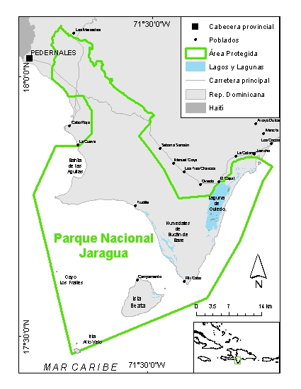
Jaragua National Park
Is located in
Barahona Peninsula, in the southwestern part of the Dominican Republic, near its
border with Haiti (Pedernales Province).
It includes the islands of Beata and Alto
Velo, as well as the cays named Los Frailes and Piedra Negra.
With an area of 1,536 km2
, it is one of the most important protected areas in the insular Caribbean.
Since 2002, it is one of the core areas of the Jaragua-Bahoruco-Enriquillo Biosphere
Reserve. Also, it is one of the Important Bird Areas (IBA)
of the Dominican Republic.
Jaragua National Park
provides an excellent representation of the pristine nature of the West Indies,
especially of arid and coastal marine ecosystems. If includes numerous
ecosysems, ranging from natural forests, beaches, rocky sores, wetlands,
seagrasses and coral reefs.
Within Jaragua, a sample of ecosystems belonging to important biogeographic
provinces of the island of Hispaniola and the West Indies can be found.
These have served as speciation centers for the rest of the Caribbean.
This makes it flora and fauna so unique, with very high levels of endemism (that
is, especies that are only found there).
This park is the only
are under protection in lowland, coastal and marine habitats from the "southern
paleoisland", one of the two islands that merged to form the current island of
Hispaniola. Since these paleoislands acted as colonization and speciation
centers, in Jaragua distinct, but closely related species converge, such as
Ricord's and Rhinocerous igunanas, and the slider turtles Trachemys stejnegeri vicina
and Trachemys decorata, among others.
Creation
Jaragua
NP was established on 11 August of 1983 by Presidential Decree
(1315), but its
current limits were defined by the Sectorial Protected Areas Law (no. 202-04).
At present, its has an area of
1,536 km²,
of which the marine areas cover some 900 km².
The studies that supported the establishment
of this Park were conducted in
1981-1982, by the Natural Resources Subsecretariat
of the Agriculture Secretariat, in cooperation with the German Social and
Technical Cooperation Service (DED). Currently the park is managed by the
Vice-ministry of Protected Areas and Biodiversity of the Ministry of Environment
and Natural Resources of the DR.
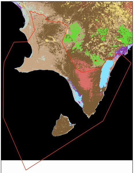
Terrain
The Parks
terrain is composed of limestone terraces of marine origin (that resemble giant
stair steps) coastal plains. A lot of the exposed limestone of its terrain has
been eroded, forming "dog tooth" limestone, which is difficult to walk on.
This natural aridity and rocky substrate have confered it a historic
protection from most human activities, allowing many unique species to survive.
This protection was reinforced when it was declared a national
park.
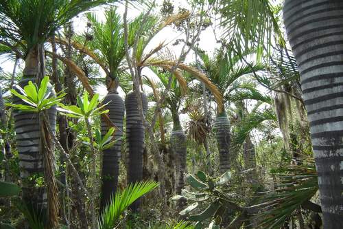
Vegetation
Twelve vegetation
types have been described for the Park. In general, it is characterized by
a great variety of plants adapted to high solar radiation and low precipitation.
There are many unique species only found in
Jaragua, including Jaragua's canelilla (Pimenta haitensis, an aromatic
and medicinal plant with a distribution almost defined by the Parks boundaries),
Gouan palm of
Cabo Rojo (Coccothrinax ekmanii), Oviedo's cacheo palm (Pseudophoenix
ekmanii) and the spiny melon cactus of Pedernales (Melocactus intortus var.
pedernalensis)
Among its marine
ecosystems one can find the most extensive and best preserved sea grass beds in
the southern coast, which support many threatened species of high commercial
value, such as queen conch (Strombus
gigas) and the spiny lobster (Panulirus argus).
Fauna
Jaragua's animals include numerous species of comercial, fishery and
biodiveristy value, including critically endangered ones (according to IUCNs Red
List).
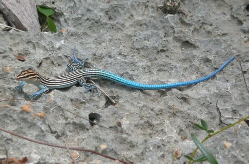
In terms
of reptiles, Jaragua has a very diverse fauna. Among its more conspicuous
reptiles are two rock iguana species: the rhinocerous iguana (Cyclura
cornuta) and the critically endangered Ricord's iguana (Cyclura ricordi),
endemic to the southwest region. The park is also the only
place in Hispaniola where all the species of some reptile genera can be found,
such as those the Ameiva lizards and the Uromacer snakes.
The park also has certain endemic species of very limited distribution, such as
the Alto Velo anole (Anolis altavelensis) and Jaraguas gecko (Sphaerodactylus ariasae).
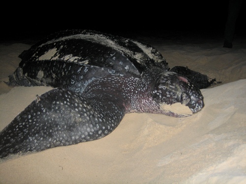
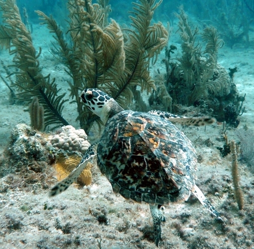
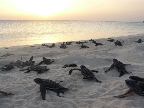
And the park's beaches are visited by marine turtles, which come to lay their
nests leatherback
(Dermochelys
coriacea) and hawksbill sea turtles
(Eretmochelys imbricata). Juvenile hawksbil land green sea
turtles (Chelonia mydas) are also found in great numbers in the coral
reef areas of the western Jaragua coast. The Park is also an important habitat
for the Hispaniolan southern slider turtle
(Trachemys decorata), endemic, and endangered.
In
addition, Jaragua is
habitat for numerous native, endemic and migratory birds. One hundreed and
thirty bird species have been reported for the park, of which 76 are native
residents, 10 are endemics and 47 migratory.
Also, the largest concentrations of White Crowned Pigeons
(Patagioenas
leucocephala) in the country are found there, which nest in large
aggregations. The Park also has the most important population of
ashy dove (Columba inornata), a threatened species in the West Indies.
In the island of Alto Velo is located the largest nesting known nesting colony
of the sooty tern (Sterna
fuscata) for the Caribbean region.
The park is also an
important reserve for the two surviving populations of the endangered and
endemic terrestrial mammals: the Hispaniolan solenodon (Solenodon paradoxus),
and hutia
(Plagiodontia aedium), as well
as 11 bat species. The West Indian manatee
(Trichechus manatus manatus),
also endangered, lives and feed on Jaragua's extensive seagrass beds. The
bottlenose dolphin (Tursiops truncatus) are also frequently spotted near
the island of Alto Velo.
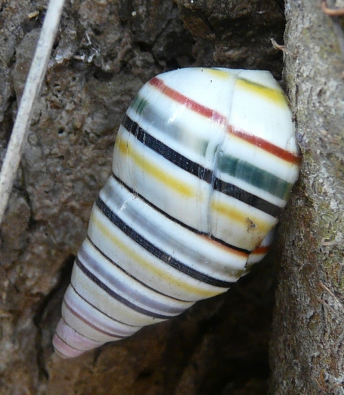
The invertabrate fauna is very little known, but recently new species for
science have been described from Jaragua.
Archaeology
Jaragua is rich in
archaeological sites from pre-hispanic times. The oldest of these sites
dates from
2,590 B.C. and corresponds to advanced indigenous people. The most sophisticated
of these cultures were the Taíno, inhabitants that practiced agroforestry, and
who dominated the island upon the arrival of Christopher Columbus.
The Taino established
certain territorial divisions of the island, known as cacicazgos. To honor
the name of the southwestern cacicazgo, Xaragua, the park takes its name.
In the park, there are a number of caves such as El Guanal, the Cueva La Poza
and Cueva Mongó,
which contain inside pictographs, petroglyphs and artifacts from this period.
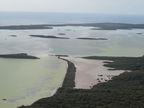
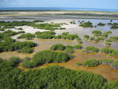
Oviedo Lagoon
Located at
the northeastern side of the Park, it measures approximately 28 km2
. Into its highly saline waters, some freshwater courses flow,
associated with extensive mangrove forests and aquatic fowl. Among
its fish species, it should be mentioned Cyprinodon
nicholsi, the largest pup fish in its family. In terms of water fowl,
the American Flamingo (Phaenicopterus ruber), and the Roseate
Spoonbills (Ajaia ajaia) colonies are some of the most
beautiful to see. Other common birds are the White Ibis (Eudocimus
albus), Great Egret, numerous terns and sandpipers. Many
of these birds nest in the cays of the lagoon or in other areas
nearby within Jaragua. The White Crowned Pigeon (Patagioenas
leucocephala), often forms it nesting aggregations in the
mangroves and forests surrounding the lagoon.
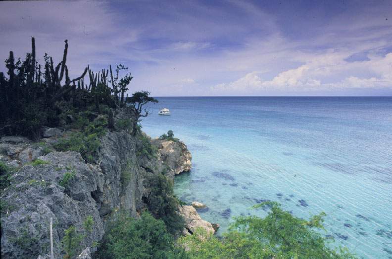
Bahía de las Aguilas
Bahía de las Aguilas
is a 4.4 km, beach located in the Parks' western side. It is, without a
doub, one of the most beautiful and best preserved beaches of the country, if
not the world. Its white, fine sands were formed by the beautiful coral
reefs that are nearshore. In this beach, leatherback (Dermochelys
coriacea) and hawksbill (Eretmochelys imbricata) sea turtles
nest. Also, near the base of the rocky terrace closer to the beach, the largest
known concentration of nesting rhinocerous iguanas (Cyclura cornuta) meets every
year.
In recent years, the
tourism development of Bahia has been a source of heated deabt in Dominican
society, occupying large spaces in the media. Due to the proximity of coral
reefs to the beach, any land-based pollution can degrade them rapidly.
Because of this, Grupo Jaragua believes taht the development model for Bahia
needs to be extremely cautios with its environment. See
Five arguments for the sustainable development of Bahia (Spanish only)
Islands
Jaragua National Park
has within its boundaries two islands (Beata and Alto Velo) as well as a small
cay formed by and emerging reef called Los Frailes.
Beata
island

La isla
Beata tiene aproximadamente unos 47 km2 de superficie. Se
encuentra a unos 6 km del sur del procurrente de Barahona. Fue
bautizada por Cristóbal Colón. Su suelo es roca caliza, y la
vegetación predominante es el bosque seco subtropical, aunque
también hay vegetación de playa, humedales salobres y manglares a lo
largo de su costa.
A
principios del s. XVII los colonizadores habían establecido fincas
ganaderas que fueron posteriormente abandonadas.
En la
actualidad, ratas, perros, gatos y cerdos cimarrones deambulan por
la isla. Entre los daños que provocan se encuentra el
saqueo de nidos de iguanas así como la depredación de iguanas
jóvenes, se comen la vegetación y son una amenaza genera a toda la
fauna nativa de la isla.
En 1959 se
estableció una colonia que funcionaba como cárcel, pero fue
abandonada 3 años después y los edificios ahora se encuentran en
ruinas. El único asentamiento permanente lo constituye un
grupo de edificios pertenecientes a la Marina de Guerra de la RD.
En toda
Beata es común ver la iguana rinoceronte (Cyclura cornuta),
especialmente en la playa de pescadores durante la época de
anidamiento.
La isla Beata tiene una herpetofauna sumamente interesante, incluyendo una importante población de la
iguana Cyclura cornuta, y la especie de reptil más pequeño del mundo, la
salamanquejita de Beata (Sphaerodactylus ariasae).
Isla Alto Velo
La isla
Alto velo consiste en un promontorio de piedra que emerge desde el
mar. La isla mide aproximadamente un kilómetro cuadrado, y su altura
máxima es de 169m. Mañón-Arredondo (1970) dice que el nombre de la isla se debe a su
majestuosa silueta que se observa a grandes distancias desde el mar,
dando la apariencia de un buque con sus velas desplegadas.
Se dice que la alta
silueta de la isla habría guiado a Cristóbal Colón hasta sus playas a finales de
agosto de 1492, cuando la descubrió y le dio el nombre de Alta Vela. Ese mismo
día, Colón había descubierto la foca del Caribe (Monachus
tropicalis) y Alto Velo era la única localidad de La Española en
que la especie había sido observada. La especie fue perseguida
a lo largo de cuatro siglos, especialmente en los siglos XVII y XVIII
por su aceite, carne y piel, hasta que desaparecieron.
La isla
Alto Velo fue muy famosa en el pasado por la explotación de guano, utilizado como
fertilizante por su alto contenido en nitrógeno y fósforo. Como parte
de la historia de la isla, en 1840 existía allí un campamento
pesquero haitiano, cuyos pescadores al parecer introdujeron chivos y perros
a la isla.
En la isla
existe un faro de concreto de unos 20 metros de altura, actualmente
en desuso y en en ruinas. Hasta
fines de los 1980s, la isla estuvo habitada por un solo marino,
encargado de la operación del faro localizado en el punto más alto
de la isla. Esta persona fue al parecer quien introdujo los
gatos a la isla.
Tanto Alto Velo como Los Frailes son de especial importancia para la anidación
de aves marinas, particularmente la gaviota ceniza (Sterna fuscata), la cual
tiene en Alto Velo su colonia de anidamiento más grande del Caribe. En
1950 se estimaron 600,000 mil huevos de la gaviota oscura (Sterna
fuscata), sin embargo, para 1979: sólo se contabilizaron 20-25 mil
aves, y se reportó que los pescadores y marinos (de la Marina de
Guerra de la RD) recogían los huevos. (Ottenwalder 1979).
La isla de
Alto Velo tiene una especie endémica, el lagarto Anolis
altavelensis.
Históricamente, Alto Velo era el único sitio de anidamiento en masa
de tortugas marinas de La Española, y probablemente de las Antillas
Mayores. Hay reportes de colecta de huevos por los
colonizadores.
Comunidades Aledañas
Existen varios asentamientos
humanos tanto dentro como fuera de los límites del Parque. Los principales
pueblos están ubicados cerca de la carretera, siendo los mayores Oviedo (2556
habitantes en 2002) y Pedernales (13114 habitantes 2002). Otros poblados menores próximos al Parque son Juancho, La Colonia (Nueva Esperanza), El Cajuil, Tres Charcos
y Manuel Goya. Dentro del Parque, existen varios campamentos pesqueros,
donde la mayoría de los pescadores residen temporalmente. Los principales
son: Trudillé, Piticabo, Isla Beata y Lanza Zó.
|


